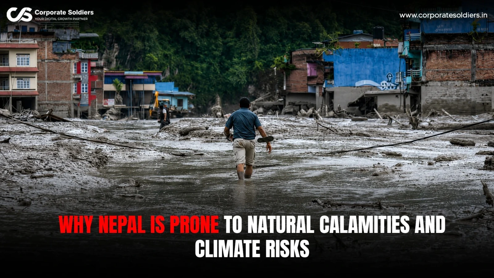
The latest disaster has included flash floods along the Bhote Koshi and other rivers in northern Nepal, killing dozens and leaving hundreds of people missing while damaging settlements, roads, bridges and hydropower infrastructure. Rescue operations have been complicated by swollen rivers, damaged roads and difficult mountain terrain.
However, climate change cannot be used to explain why Nepal is vulnerable to natural disasters. Its disaster risk is the combination of many factors: active tectonic environment, steep Himalayan terrain, weak geology, heavy monsoon downpours, shifting snow and glaciers, and increasing human exposure to the hazardous regions. This combination has once more been highlighted in recent coverage of Nepal and its vulnerability.
That is, Nepal is not simply a country that is prone to a large number of natural hazards. The physical environment and development trends of the country can transform those risks into the most disastrous ones.
Nepal’s Unique Geographic Position
Nepal is situated in a relatively small area between the high Himalayas on one side and the plains of the Terai on the other. The country travels through significant alterations in height, landscape, climate and river systems in a relatively small horizontal distance.
This topography brings varying shapes of exposure in the country. There are snowfields, steep valleys and glaciers in the high mountains. The middle hills are steep sided with deep cut valley in between and there are broad plains in the Terai, where the large rivers forming out of the Himalayas pass on their way to the Ganges basin.
It implies that the same wider weather system could cause various hazards in the various regions of Nepal. Excessive rainfall can cause a mountain slope in the hills to collapse, and at the same time, it raises the level of rivers in the lower part of the river. A river may be blocked due to a landslide and a secondary flood risk will have been formed, and a damage of a road or bridge may leave the community without access to emergency services.
The river systems in Nepal thus relate hazards over elevation ranges. What seems as a mountain incident might turn out to be a downstream calamity.
Why Nepal Is Vulnerable to Earthquakes
The earthquakes are a constituent of the long-term disaster risk in Nepal due to the fact that the nation is located in the active collision zone of the Indian and Eurasian tectonic plates.
The Indian Plate is moving northward at roughly 5 cm a year, converging with and pushing beneath the Eurasian Plate, building enormous geological pressure that is periodically released through earthquakes.
This is what renders the risk of earthquake in Nepal entirely different to the seasonal risks experienced in Nepal like the monsoon flooding. The weather can be unpredictable every year, yet the tectonic environment is something that the country can never be free of.
The magnitude 7.8 earthquake struck on April 25, 2015, followed by another powerful magnitude 7.3 tremor on May 12. Nearly 9,000 people were killed and more than 22,000 injured, while more than 500,000 houses were destroyed and around 270,000 more were damaged.
Earthquake risk is also influenced by local ground conditions. In the Kathmandu Valley, deep layers of clay can contribute to soil liquefaction during strong shaking when water-saturated soil loses strength. This can increase damage to buildings, roads and other infrastructure.
Cascading hazards can also be caused by earthquakes. Powerful shaking may cause slopes of mountains to become unstable, activate landslides and avalanches, damage roads and bridges, interfere with water, electricity and telecommunications infrastructure. In mountainous land, then, the effects of an earthquake may persist long after the shaking of the ground has begun.
The Fragile Himalayan Terrain
Nepal’s Himalayan landscape is both spectacular and physically challenging.
The Himalayas are a young and tectonically active system of mountains. Their sharp slopes, broken rocky structures, heavy erosion and fast flowing rivers make the environment where slope stability can be easily influenced by nature processes.
The earthquakes, heavy rainfall and other causes of slope disturbances can cause landslides. Slopes may be eroded by the river, and heavy rainfall may saturate the soil and weaken the already weak soil.
Another vulnerability can be human activity. Slopes may be disturbed or more water and sediment may pass through mountain catchments due to road construction, excavation, clearing of forests, improperly planned settlements and insufficient drainage.
This difference is significant since a hazard does not necessarily turn out to be a disaster. A hazard is a potentially harmful natural occurrence or process. The disaster risk arises when that hazard is combined with the exposed individuals, structures, infrastructure, and livelihoods, which might not be adequately prepared or strong enough.
The Role of Nepal’s Monsoon
One of the most relevant factors affecting the disaster profile of Nepal is the South Asian monsoon.
The annual rainfall in Nepal is a big proportion of the monsoon rain. Extensive or intensive rainfall may cause a sudden increase in river flow, saturate the slopes and create run off along steep slopes.
The effects may include flooding of rivers, flash floods, landslides, and debris flows and extreme soil erosion. The evaluation of the disaster situation in Nepal conducted by UNICEF outlines floods and landslides as the significant hazards in the country and adds that the presence of these events is strongly related to the geography and topography, the high level of precipitation, and environmental factors.
Rain-induced hazards can be particularly speedy in mountainous areas. Rapid streams may accumulate a lot of energy and transport sediment, rocks and other debris on their downward path to the settlements and valleys.
Nevertheless, one should not think that all extreme rainfall events are the result of climate change. Naturally, weather changes, and there are numerous physical drivers to individual events. The current question is what might be the impact of long-term shifts in temperature and precipitation patterns on the level of risk background.
How Climate Change Is Changing Nepal’s Risk Profile
Climate change is more of a risk multiplier in Nepal other than the only cause of natural calamities in Nepal.
According to the World Bank, Nepal is already feeling the effects of climate and higher temperatures, shifts in precipitation and glaciers are set to enhance stress due to hazards such as flooding and landslides.
Rising Temperatures
The impacts of warming on the mountain environment in Nepal are interconnected in many ways.
Snow and ice alterations can affect the seasonal runoff and warming also stresses high-altitude ecosystems and water resources. Since the Nepal communities, farms and economic activities mainly rely on the mountain water systems, the alteration of the time and supply of water can pose threats even without the sudden calamity.
Changing Precipitation
Climate change may cause a variation in the timing, intensity and distribution of rainfall. Studies and climate analyses of Nepal show that there is an issue of variable rainfall distribution, with increasing rainfalls and water scarcity periods.
The key thing is that climate change does not have the same effect on Nepal as a whole. The various areas might face varying blends of flood, landslide, drought, heat and water hazards.
Glacier Retreat
Warming is especially sensitive in the Himalayan cryosphere.
Glaciers play a significant role in the Nepal water system of the mountains, whereas the increasing temperatures are contributing to the glacier melting and alteration of glacier based river systems. ICIMOD reports that since the mid-20th century the Himalayan glaciers have been melting and retreating at unprecedented rates, which have been adding to the creation and growth of glacial lakes.
This makes a risk profile complex. Glacial and snowmelt are essential water sources, and modifications in the high-mountain environment may also pose new threats.
What are Glacial Lake Outburst Floods?
A Glacial Lake Outburst Flood, or GLOF, is the sudden release of water in a glacial lake, which could cause a massive wave of water flowing downstream.
The process may evolve in a number of steps:
- Due to climate warming, a glacier retreats or alters.
- The meltwater is built up in a depression or behind a natural dam.
- The glacial lake swells or its environment is destabilized.
- The natural dam may be overtopped or fail.
- Massive amounts of water may quickly flow down the river, transporting sediment and debris.
GLOFs are of special interest due to the fact that the people who are at the risk can be at a great distance to the source lake. The flood is able to move along interconnected valleys and river networks and destroy bridges, roads, settlements, and other infrastructure.
The historical importance of GLOFs has been documented in Nepal by ICIMOD and that these events may cause cascade effects such as landslides, erosion and sedimentation.
Climate change would thus be pertinent to the risk of GLOF since the warming process may lead to the retreat of glaciers and expansion of glacial-lake. It is not these that climate change is the direct cause of all GLOFs, what may cause an immediate trigger is avalanches, rockfalls, natural-dam instability or other mechanisms.
Floods and Landslides: Nepal’s Recurring Threats
Some of the most common natural hazards in Nepal are floods and landslides.
Their repetition is the intercourse of the monsoon rainfall, steepness of the terrain, river system, erosion and human exposure.
One event may be triggered by another. For example:
Heavy rainfall → slope failure → landslide → blocked river → downstream flooding
This is known as a cascading hazard sequence. The original event does not necessarily remain confined to one location or one type of damage.
Recent floods have illustrated this interconnected vulnerability. UNICEF has reported that heavy rainfall and landslides can damage houses, schools, health facilities, water systems and major roads, with blocked transport routes making emergency response more difficult.
How Human Activity Can Increase Disaster Risk
Only a part of the equation is natural hazards.
Unplanned urbanisation, the building on unstable slopes, the lack of drainage, the settlement along rivers, as well as the poorly designed roads may make people more exposed and vulnerable. Land-use and deforestation can also affect the erosion and slope conditions.
One of the major issues especially in mountainous regions is road construction. Roads play a vital role in the economic growth of Nepal and in linking remote communities, however, excavation into steep slopes without proper geological evaluation of these slopes, drainage or slope stabilisation may make it more prone to landslides.
These activities may not necessarily cause the underlying earthquake, rainfall or mountain slope hazard. Rather, human development can make natural events more likely to be disastrous.
Why Infrastructure Is Particularly Vulnerable
Development of infrastructure is normally challenging in Nepal due to its topography.
The mountain roads and bridges tend to run in deep valleys and steep slopes. Hydropower plants rely on river systems which are subject to flooding, landslides and silt. Transport corridors may be destroyed making schools, hospitals, electricity networks, water systems and telecommunications infrastructure hard to reach or restore.
This multiplies out.
In case a road is blocked by a landslide, it may not necessarily destroy the road. It is able to slow down ambulances, and hinder the delivery of food and medical supplies to communities as well as hinder rescue efforts. UNICEF has reported incidences where landslides and broken roads have greatly contributed to access difficulties of the affected communities.
Why Communities Face Unequal Disaster Risk
Social and economic conditions also determine the disaster risk.
Remote communities might face a lack of access to hospitals, emergency facilities and to reliable communications. When households have less resources, they can potentially have more difficulties constructing resilient houses, moving out of the areas at risk or post-disaster recovery of crops, livestock, houses or income.
The World Bank observes that the poor and the vulnerable may end up bearing the brunt of climate and disaster effects.
This is especially vulnerable to Agriculture whose production is directly impacted by rainfall, temperature, floods, drought and water availability. The mountain environment in Nepal is also linked to tourism and hydropower, implying that disasters can impact not only livelihoods, but the overall economic activity as well.
A Country Facing Multiple Hazards at Once
The profile of disasters in Nepal is thus clearly multi-hazard.
Earthquakes, landslides, river floods, flash floods, GLOFs, avalanches, drought, heat waves, cold waves, wildfires, lightning and severe storms are experienced in the country. In its analysis of the disaster exposure of Nepal, UNICEF recognizes geological and hydro-meteorological hazards as key aspects of the entire disaster exposure.
Such hazards do not necessarily come in isolation.
Landslides may result as a consequence of an earthquake. The river may be blocked by a landslide. Floods may cause instability in the blockage resulting in floods. Events that are related to glaciers may interact with avalanches, rockfalls, erosion and downstream flooding.
It is one of the reasons why disaster planning in Nepal should not continue to prepare for specific events that are not intertwined.
Climate Change and the Himalayan Water System
Himalayan warming has more than immediate impacts of unexpected floods and landslides.
Seasonal river flows, agriculture, hydropower and drinking-water supplies can be impacted by changes in the amount of melt-off of snow and glaciers. Water, agriculture and forests are the three systems connected and need to be planned together in climate-resilience planning in Nepal as identified by the World Bank.
In the mountain river-based country where agriculture, power production, and population rely on the water cycle, alterations in the water cycle can generate both slow-acting stresses and catastrophes.
Climate adaptation is, therefore, not only an environmental, but a development issue.
Why Disaster Preparedness Matters
Nepal is not able to eradicate the tectonic forces under the Himalayas or to flatten its mountains. However, it is able to mitigate the effects of natural hazards.
Early-Warning Systems
Early warnings will provide communities with good time to vacate flood paths and other places that are prone to danger. Forecasting and river-monitoring systems have already been deployed in Nepal to aid the anticipatory measures of river basins that are prone to floods.
Risk Mapping
Hazard maps can be used in detail to guide authorities on the areas at risk of landslides, floods, unstable slopes and other challenges prior to the approval of new settlements and infrastructure.
Climate-Resilient Infrastructure
The hazardous environment of the country is changing and roads, bridges, drainage systems, hospitals, schools and water infrastructure should be designed to consider the changing environment.
Earthquake-Resistant Construction
Since seismic risk is irreversible, proper building codes and their implementation is a necessary thing. The 2015 earthquake experience has shown that the quality of construction and resilience of infrastructure can affect the consequences of disasters to a significant extent.
Community Preparedness
Roads and official emergency networks could be broken resulting in a significant difference in evacuation routes, emergency communication, local response teams and public awareness.
Nepal’s Challenge Is Not Just Climate Change
To make Nepal less susceptible to the effects of natural disasters the bigger picture needs to be taken into consideration.
The combination of tectonic activity, steep topography, weak geology, monsoon weather, shifting climate conditions, glaciers, land use, infrastructure, population exposure, poverty and preparedness are some of the factors that make it risky.
With climate change, a number of risks may be exacerbated, especially those related to excessive rainfall, water systems, glacier change and heat. Earthquakes are mainly caused by tectonic processes and landslides and floods have several causes that interrelate with each other.
This distinction matters. Viewing all disasters as impacts of climate change may distract the equally significant contribution of geology, development planning and preparedness to disasters.
What the Increasing Risk Means for Nepal
There is more than immediate loss and damage.
Frequent calamities may interfere with tourism, agriculture, hydropower generation, education, medical care, transportation and local industries. They are able to destroy the infrastructures of the people, disrupt supply chains and compel households to use the little resources on recovery instead of development.
The World Bank has cautioned that climate and disaster risks are posing a threat to the development gains of Nepal and it is advisable that the resilience be enhanced in such areas as roads, water, agriculture, urbanisation and community assets.
In the case of Nepal however, disaster-risk reduction and climate adaptation cannot be considered as different policy areas. To safeguard development, both are needed.
Final Thoughts
The susceptibility of Nepal to natural disaster lies first in the natural environment of Nepal. The nation lies on an active tectonic fault, on steep and geologically youthful mountainous landscape, receives heavy seasonal precipitation and features large glacier-based rivers.
Another dimension to this already complicated risk scenario is climate change. Rising temperatures, altered precipitation, melting glaciers and altering water regimes can lead to stress on populations and infrastructure and human activities in vulnerable regions can amplify the effects of natural hazards.
The main question is not thus whether Nepal is capable of averting natural hazards. It is unable to stop earthquakes, remove the monsoon rainfall or reform its mountainous terrain.
What it could accomplish is to decrease the possibility of hazards turning into catastrophes.
Disaster losses can be mitigated by improving land-use planning, resilient infrastructure, earthquake-safe construction, early-warning systems, monitoring of glaciers and rivers, building of resilient emergency networks and community preparedness.
In the case of Nepal, resilience is not merely a response to climate. It is a long term development need which is influenced by the Himalaya realities.